
GEOKURS CHCNAV X500 Quadcopter
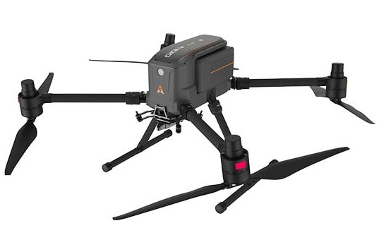
The CHCNAV X500 professional rotary UAV is designed for heavy payloads and extended flight times. Equipped with a modern flight control system and high-precision positioning, it provides excellent maneuverability, stable flight performance, and industry-standard stability. Built-in SLAM visual navigation technologies and an obstacle avoidance radar enable intelligent flight modes, enhancing mission efficiency and safety. The X500 supports a payload of up to 5 kg and provides a flight endurance of up to 58 minutes, or up to 50 minutes when equipped with a CHCNAV AA10 lidar. IP55 protection and wind resistance of up to 12 m/s ensure reliable operation in challenging operating conditions.
The X500 supports up to three payloads and is compatible with CHCNAV lidars and cameras. An open SDK interface simplifies the integration of third-party devices and allows the platform to be customized for specific applications. The use of the universal Mavlink protocol ensures flexibility and applicability in a variety of scenarios.
The X500 is equipped with an advanced redundancy system: dual GNSS, triple IMU redundancy, a duplicated flight controller, and safe return strategies. Millimeter-wave radar ensures precise detection and avoidance of obstacles, including trees, buildings, and towers. The vSLAM visual positioning system enables landing on moving vehicles and vessels.
The X500 uses the CHCNAV video transmission system, providing a range of up to 20 km. Advanced algorithms optimize wireless HD video transmission, reducing latency and increasing communication reliability. A 1080p FPV video stream and a remote control with a large 10.1-inch screen provide convenient and intuitive control. When paired with the BS10 charging station, which holds up to six batteries, it provides a rapid charge from 20% to 90% in just 40 minutes, enabling continuous operation all day long.
The CHCNAV SmartGo ground control software supports various flight path types, including rectangular, linear, polygonal, and façade. The software displays the UAV's status, course, and surrounding obstacles in real time, enhancing safety during beyond-visual-line-of-sight (BVLOS) flights.
 The CHCNAV X500 professional rotary UAV is equipped with the AlphaAir 10 (AA10). This state-of-the-art airborne lidar imaging system combines LiDAR and an RGB camera in a single compact module. It is designed for professional UAV mapping and photogrammetry applications where high accuracy, speed, and consistent results are essential. The AA10 combines high-precision lidar, GNSS navigation, a reliable IMU, and an industrial-grade full-frame camera. When paired with CHCNAV's point cloud and image fusion software, the system provides a high-quality and cost-effective approach to collecting and processing 3D data. High accuracy and advanced scanning capabilities
The AA10 navigation algorithm, combined with the CHCNAV LiDAR scanner, achieves:
- repeatable accuracy of up to 5 mm,
- absolute accuracy of 2–5 cm even in challenging conditions,
- scanning range of up to 800 m,
- a scanning speed of 500,000 points/sec,
- a scanning frequency of up to 250 lines/sec thanks to a rotating mirror.
These parameters ensure highly detailed and accurate models even over large areas.
Real-time: stitching, viewing, and modeling
The AA10 significantly accelerates the creation of 3D models thanks to:
- an integrated 45 MP orthocamera providing detailed texture;
- generation of accurate and dense point clouds;
- real-time viewing of results directly from the UAV controller;
- support for automatic surveying and visualization on the job site.
CHCNAV CoPre and CoProcess software simplifies post-processing, modeling, and feature extraction, making the workflow as user-friendly as possible.
Improved Vegetation Penetration
The AA10 supports up to 8 echoes, significantly improving penetration under foliage and dense vegetation. This enables accurate terrain data acquisition and the construction of precise DEM/DSM, even in challenging environmental conditions.

